
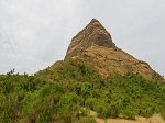
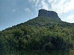
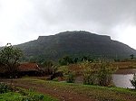
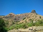
🏰 Achala Fort (अचला किल्ला)
Achala Fort, locally known as Achala Killa, lies on the western edge of the Satmala mountain range. It is situated around 55 km from Nashik city, and stands very close to Ahivant Fort. Along with Mohandar and Ahivant, this fort forms part of a strategic hill complex. Achala and Mohandar were mainly built to guard and protect the important Ahivant Fort. Historical notes mention that the hill is easy to climb initially, but towards the top, the slope becomes sharply steep.
📜 History of Achala Fort
In 1636, Achala Fort was under the Adilshahi rule.
During the Mughal expansion in this region, Shaista Khan was given the task of capturing forts in Nashik. His officer Alivardi Khan gained control of Achala.
In 1670, Chhatrapati Shivaji Maharaj successfully recovered this fort from the Mughals during his widespread campaign.
Later, the Mughals launched another massive attack under Mahabat Khan, supported by Diler Khan. As the battle intensified, Ahivant Fort surrendered first, and Achala also fell soon after.
After the downfall of Trimbak Fort in 1818, Achala was finally handed over to the British, along with 17 other forts.
🧭 How to Reach Achala Fort
The nearest major town is Vani, about 44 km from Nashik.
The trek usually starts from Dagad Pimpri village, which is around 13 km from Vani.
Lodging facilities and eateries are easily available at Vani.
The route begins from a small hill north of Dagad Pimpri. It is a wide, safe, and mostly treeless trail, taking about one hour to reach the col between Achala and Ahivant Fort.
From this point, the right trail goes to Ahivant, and the left leads to Achala.
Night stay on the fort is not possible due to lack of drinking water. Local villagers, however, arrange food and stay in nearby settlements at reasonable cost.
Another access route to the fort is available from Daregaon village.
📍 Places to See on Achala Fort
Achala is a small hill fort, and the top area can be explored in roughly 30 minutes. Visitors can still view:
Remains of old structures and storage rooms
Ruined building foundations
A few water tanks and stone cut cisterns
Although not much remains today, the fort offers scenic views of adjoining hills and neighboring forts, especially Ahivant.
 🏔️ Alang Fort (Alang Gad) – Nashik
Alang Fort, also known as Alanggad, is a high-altitude hill fort in the Igatpuri–Trimbak region of Nashik district, Maharashtra. It forms a trio with Madan Fort (Madan Gad) and Kulang Fort (Kulang Gad) in the Kalsubai mountain range of the Western Ghats. These three forts are extremely popular among trekkers because of their difficult terrain, dense forest routes, and challenging rock climbs. Due to heavy rainfall and tough trails, the area is still less crowded compared to other trekking destinations in Maharashtra.
🚶♂️ How to Reach Alang Fort
Travelers can begin their journey from Kasara or Igatpuri railway stations.
From there, follow the Igatpuri/Kasara → Ghoti → Pimpalner → Ambevadi route.
Ambevadi village is the base point for the trek and is connected by local buses from Ghoti. The distance between Ghoti and Ambevadi is around 32 km.
From Ambevadi, the trail leads toward the ridge between Alang and Madan. The initial ascent may take about 3 hours.
Once on the ridge, Alang lies towards the left and Madan towards the right.
There are two main trekking routes to reach Alang:
🟢 Route 1 (moderate + technical)
Descend a little from the ridge to reach a plateau.
Continue walking with Alang on your left.
Reach a cave after about an hour.
From here, rock-climbing sections lead upward to the fort top.
Time required: 8–9 hours (from base village).
🔴 Route 2 (for trained climbers only)
Straight climb from the ridge.
Includes rock patches and a broken pinnacle around 80–90 feet high.
Only experienced trekkers with equipment should attempt this route.
Time required: 6 hours (faster but technical).
👣 What to See on Alang Fort
The top of Alang is a large rocky plateau.
The fort contains:
Two spacious caves
A small temple
Around eleven water tanks/cisterns, which hold water throughout the year
Ruins of ancient structures, indicating past settlements
The peak gives a spectacular 360° view of other famous Sahyadri forts:
East: Kalsubai peak, Aundha, Patta, Bitangad
North: Harihar, Trimbakgad, Anjaneri
South: Harishchandragad, Ajoba, Ratangad, Khutta pinnacle, Katrabai
🌧️ Best Time to Visit
Post-monsoon to winter (October–February) is ideal due to clear routes and safer rock patches.
⚠️ Trek Difficulty & Safety Tips
Grade: Difficult
Recommended for experienced trekkers only
Carry:
Climbing gear (ropes, harness)
Food and torch
Proper trekking shoes
Avoid trekking during heavy monsoon rains
 🏰 Ankai Fort (अंकाई किल्ला) – Overview
Ankai, also known locally as अणकाई, is a prominent hill fort on the Satmala mountain range in Yeola Taluka, Nashik district. The fort stands close to Manmad and is paired with the adjoining Tankai Fort, both surrounded by naturally steep cliffs. A single protective wall covers the saddle between these twin hills, making them appear like one huge fortress. Ankai is placed on a high rock face with sheer drops on all sides, except for a small ridge on the east which forms the only accessible approach.
📜 Historical Background
Evidence such as Brahmani (Hindu) caves on the fort and Jain caves at its foothills suggest Ankai’s origin to be around a thousand years old. It is believed to have been constructed during the rule of the Yadava dynasty of Devgiri.
In 1635, the fort fell to Mughal forces under General Khan Khanan, who allegedly acquired control through bribing the fort commander. European traveler Thevenot mentioned Ankai as an important stop on the Surat–Aurangabad route in 1665.
The fort later came under the Nizam, followed by the Marathas in 1752 through the Bhalki treaty. Eventually, in 1818, the British took control during the widespread capture of Deccan forts.
🛣️ How to Reach
Nearest Town: Manmad, about 97 km from Nashik.
Base Village: Ankai, roughly 10 km from Manmad.
🔀 Road Routes from Nashik:
Via Manmad (shortest & convenient)
Via Vinchur – Lasalgaon – Patoda (~85 km)
Via Yeola (~108 km)
Ankai has a nearby railway station, where many passenger trains on the Manmad–Nizamabad line halt.
The trek begins from the northern side of Ankai village. The route is wide, safe, and equipped with carved stone steps right up to the entrance. The trail has no shade, so early morning trekking is recommended. Reaching the gate takes around 30 minutes, and exploring both forts together usually requires 2.5–3 hours.
Basic food, tea, snacks, and overnight shelter are available in the village temples, with local residents assisting trekkers if required.
📍 Attractions & Places to See
🕉️ Jain Caves
Situated at the foothill, these caves are carved in two levels.
Lower level: Two caves without idols
Upper level: Five beautifully sculpted caves with images of Lord Mahavir, protected with locks at night.
Carvings include Yaksha, Indrani, lotus motifs, and detailed figures of Ambika and Kichaka. There are potable water cisterns nearby.
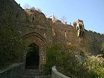
🚪 Main Gate
Located to the south, the sturdy entrance still showcases old wooden architectural remnants.
🚪 Manmad Gate
This gateway faces the town of Manmad on the northern col, offering a panoramic view.
🏞️ Brahmani (Hindu) Caves
Close to the upper plateau entrance. Though partially damaged, sculptures of Jai–Vijay and a carved Shivling are still visible.
🪜 Rock-Cut Pathway
A series of stone steps runs through four defensive gateways, leading to the top of Ankai.
🏰 Ruined Palace & Kashi Pond
On the west of the plateau lies a palace site, now in ruins, with only its walls intact. A small Dargah room still stands. Nearby, a unique stone-carved Kashi pond contains a rock-engraved Tulsi vessel at its center.
Several other water cisterns can also be found across the hilltop.
🕒 Time required to explore: Around 2 hours for the complete fort.
 🏰 Bhaskargad / Basgad Fort
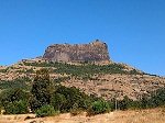
Bhaskargad, also known as Basgad, is a hill fort located close to Igatpuri in Nashik district, Maharashtra. It lies in the same mountain belt as the Trimbakeshwar range and stands near the popular Harihar Fort. The fort is small in size but is known for its scenic trail, unique rock-cut staircase, and panoramic views of the surrounding Sahyadri hills.
📜 History
Bhaskargad is believed to have originated during the rule of the Yadava dynasty of Deogiri. Between the late 13th and early 14th century, the Yadavas held control over the fort. Over the following centuries, the fort changed hands several times—first ruled by the Bahamani Sultanate and later by the Nizam rulers of Ahmednagar.
During the 17th century, Shahaji Raje Bhosale took control of the fort while resisting the rule of Bijapur. Later, it was again captured by the Adil Shahi forces, followed by Mughal occupation in 1633. In 1670, Shivaji Maharaj’s commander Moropant Pingale won the fort back from the Mughals. After another brief Mughal hold around 1688, the Koli community took charge of the fort in 1730. Eventually, Bhaskargad came under Peshwa administration and finally passed into British hands in 1818 under Captain Briggs of the East India Company.
🚶♂️ How to Reach
The base village for the trek is Dahalepada, which can be approached from two directions—either via Khodala or from Igatpuri. Igatpuri is the nearest major town, located approximately 48 km from Nashik and around 121 km from Mumbai. Accommodation and food options are available at Igatpuri and Ghoti.
The trekking route starts from a hillock south of Dahalepada. The trail is wide, safe, and mostly passes through shrubs and open ridges. Once near the fort’s base wall, trekkers walk along a long traverse with rocky overhangs and thick Karvi bushes. The highlight of the climb is a set of rock-cut steps that spiral upward in a helical form. These steps are easy to climb, but some portions are covered with loose stones and boulders. It generally takes around 1 hour to reach the base wall from the village and around 15 minutes more to reach the top.
💧 Note: There is no drinking water or shelter on the fort; therefore, trekkers must carry their own water and avoid overnight stay.
👀 Places to See
Rock-cut Entrance & Steps: The main entrance and staircase are carved directly into the hill’s rock, giving the fort a distinctive architectural look.
Water Cistern: A small rock-cut tank can be seen on the fort, though it is usually dry.
Veer Maruti Idol: A simple stone idol of Lord Hanuman (Maruti) can be seen on the fort.
Exploring the entire top area usually takes about 20–30 minutes.
 🏰 Chandwad Fort (Chandor Fort | चांदवड किल्ला)
Chandwad Fort, also called Chandor Fort, stands close to the town of Chandwad in Nashik district, around 10 km from the settlement. Positioned on a hill range, the fort offers a commanding view of the surrounding region and has historically protected the route linking Khandesh and Nashik.
📜 Historical Background
The fort is believed to have been built around the 9th century (around AD 801) during the period of Dridhaprahara, who laid the foundation of the early Yadava dynasty at Chandor. In the medieval period, this stronghold overlooked the important pass used for trade caravans, making it a strategic checkpoint.
During the rule of King Bhoj, the area gained religious significance, with several temples said to have been established in the region. Folklore also connects the fort to Princess Chandrakala, who was married at this location to King Vikram, emphasizing its cultural importance.
Over the centuries, the fort changed hands multiple times. It was governed by the Bahmani Sultanate, later seized by Mughal forces in 1635, and again captured by the Maratha Empire in 1665. Eventually, during Aurangzeb’s expansion, the Mughal army regained control.
By the mid-18th century, Malharrao Holkar encouraged artisans to settle in Chandwad by gifting land, leading the town to become widely known for its skilled brass work. In the British campaign of 1818, the fort was surrendered after surrounding forts such as Ankai and Tankai fell. During the 1857 rebellion, the 24th Maratha Regiment occupied the fort for a brief period before it was retaken by the British in 1859.
The establishment of the Manmad railway depot in 1861 shifted trade routes away from Chandwad, reducing the fort’s strategic and commercial value. Today, the site remains a symbol of the region’s layered history and forgotten trade heritage.
🌄 Present-day Relevance
Visitors today explore Chandwad Fort for its historic architecture, scenic views, and forgotten legends. The hill fort is a reminder of how trade, dynasties, and craftsmanship shaped the town’s identity over more than a thousand years.
 🏰 Galna Fort
Galna Fort (गाळणा किल्ला) stands in the rugged hill ranges between Malegaon and Dhule, in the southern part of Khandesh, Maharashtra. This fort once played a strategic role on the historic trade road connecting Burhanpur and Surat. The fort’s main gate and bastions are still comparatively well-preserved, making it a notable structure among the forts of the region.
📜 Historical Background of Galna Fort
During the late 15th century, Galna emerged as a significant military and administrative point near the Deccan frontier. It remained under local rulers until 1487, when Malik Ashraf and Malik Waji, the governors of Daulatabad, seized control. After Malik Waji was killed in 1506, the fort fell to Malik Ahmed Shah Nizam of Ahmadnagar.
Following his death in 1510, the fort again changed hands when the ruling commander refused to pay tribute to the Deccan power. By 1634, Galna’s Muslim commander, Muhammad Khan, agreed to pay revenue to the Mughals, marking a shift in authority.
The fort came under further turmoil when Aurangzeb attacked it in 1704, capturing it the following year. Later, in 1804, the British officer Captain Wallace took possession from the Holkars. By March 1818, native infantry occupied Galna, and for a brief period afterward, a mamlatdar office functioned here.
🗺️ How to Reach Galna Fort
Galna lies in Malegaon Taluka of Nashik district. The base village, also named Galna/Dongarale, is connected by road to both Malegaon and Dhule. Buses regularly travel from Malegaon to Dongarale, which is around 25–30 km from either town. From Dongarale, the fort base is roughly 4 km, and trekking leads to the fort entrance.
 🏰 Harihar Fort (Harshagad)
Harihar Fort, also known locally as Harshagad, stands prominently near the Trimbakeshwar region in Nashik district, Maharashtra. Situated close to Igatpuri, the fort is famous for its steep, vertically carved stone steps, which attract thousands of adventure lovers and trekkers every year. This hill fortress kept watch over the ancient trade route that once passed through the Gonda Ghat, making it a strategically important structure in the past.
📜 Historical Background
The origin of Harihar Fort dates back to the Yadava dynasty, when it served as a protective outpost on key commercial routes. Later, during the 17th century, the fort changed hands several times. In 1636, Shahaji Raje Bhosale handed the fort over to Khan Zaman, along with several others from the Trimbak region. In the final phase of the Maratha–British conflicts, the fort was seized in 1818 by British officer Captain Briggs, along with a group of nearby hill forts.
🧗♂️ How to Reach Harihar Fort
Trekking to Harihar Fort is possible from two main base villages:
📍 1. Harshewadi
Approximately 13 km from Trimbakeshwar
Offers a relatively easier and shorter climb
Best suited for beginners and moderate trekkers
📍 2. Nirgudpada (Kotamvade)
Located about 48 km from Igatpuri, which is well-connected to Nashik (48 km) and Mumbai (121 km)
A well-defined trekking trail begins from a small hillock north of the village
The route goes through small forest patches and an open ridge leading directly to the fort base
⛰️ Trek Experience
The highlight of the Harihar trek is its nearly vertical staircase, carved directly into the rock face.
The stone ladder rises almost 60 meters, tilted at around 60 degrees
The steps are narrow at several points, allowing passage for only one person at a time
Handholds carved into the rock make the climb thrilling yet safe for first-time trekkers
After reaching the top entrance, another spiral set of steps leads to a narrow gateway opening onto the fort plateau
Accommodation is available both on the fort (basic shelter) and in nearby villages, where locals also offer food and guidance.
🌄 Why Visit Harihar Fort?
Adventurous almost-vertical climb
Stunning views of surrounding peaks and valleys
A unique example of old rock-cut architecture
Ideal for photography, trekking groups, and history enthusiasts
 🏞️ Indrai (Indragiri) Fort – Chandwad, Nashik
Indrai Fort, also known as Indragiri, lies in the Satmala mountain range near Chandwad in Nashik district. Although it is an ancient hill fort, it remains comparatively lesser known among trekking enthusiasts. In this range, four forts stand in a row — Chandwad, Indrai, Rajdher and Koldher, forming a scenic chain of hilltop strongholds. The trek to Indrai Fort is considered easy, and usually takes around 3 hours from the base village.
📜 Historical Background
Very little documented history is available about Indrai Fort. The fort came under British control in 1818. It is believed that the local garrison surrendered after witnessing the fall and destruction of the nearby Rajdher Fort during the same campaign.
🧗 How to Reach the Fort
Nearest town: Chandwad (approximately 69 km from Nashik)
Base village: Indraiwadi (around 9 km from Chandwad)
Chandwad has lodging facilities, while Indraiwadi provides basic snacks and tea options for trekkers. The trail begins from a small hill near Indraiwadi and passes through thick scrub vegetation. Although the route is safe, it is not well-marked, so hiring a local guide is recommended.
The trek takes about 2 hours to reach the base of the cliff, followed by a stretch of narrow trail leading to rock-cut steps— nearly 150 steps, about 2 meters wide, which can be climbed in roughly 15 minutes. Although the fort’s entrance structure is not visible today, there is abundant freshwater available at the top. Night stays are possible inside the caves on the fort.
📍 Places to Explore on Indrai Fort
Unique rock-cut steps forming a gorge-like passage
Persian inscription carved near the entrance area
Numerous rock-cut water cisterns
Remains of ancient administrative structures (Kacheri)
A small Mahadev temple
Nearly 10 rocky caves, suitable for night halts
Exploring all major spots on the fort generally takes about one hour.
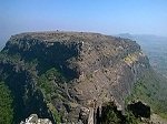
 🏞️ Tringalwadi Fort – Igatpuri, Nashik
Tringalwadi Fort stands in the picturesque Igatpuri region of Nashik district and lies close to the small settlement of Tringalwadi. This hill fort rises beside the old trade route that once crossed the Thal Ghat, connecting the coastal Konkan areas with the Nashik region. Near the base of this fort is the Tringalwadi Dam, a local irrigation lake constructed in the late 1970s.
🏛️ Historical Background
The ancient caves found at the foothills suggest that the fort and cave structures probably date back to around the 10th century. Tringalwadi was strategically located to monitor traders passing between the Konkan ports and the Deccan region. After Shahaji, father of Chhatrapati Shivaji Maharaj, was defeated at the Mahuli Fort in 1636, this fort went under Mughal control. Though the timeline of Shivaji Maharaj’s capture of Tringalwadi is unclear, historical records show that the Mughals once again gained possession of it in 1688. In 1818, after the fall of the nearby Trymbakgad Fort, Tringalwadi was one of the sixteen forts handed over to the British.
🚗 How to Reach
Tringalwadi village lies roughly 7 km away from Igatpuri town, which is well connected by the Mumbai–Nashik railway and by National Highway NH-160. Travelers can reach the fort through two routes:
From Igatpuri town itself
Or via Ghoti, moving north from NH-160 and passing through Balayaduri village
The fort occupies a flat-topped hill with a mesa-type rock formation. The ascent from the village is easy and typically takes around 30 minutes to reach the summit.
🌄 What to Explore
At the base of the fort is a beautifully carved rock-cut cave known as Pandav Leni, featuring a stone idol of Bhagwan Rishabhanatha in the sanctum and a spacious assembly hall. The fort’s western entrance is especially striking — the gateway and steps are sculpted out of a single rock. A statue of Veer Hanuman (Maruti) stands near this entrance, while two carved Sharabha figures appear above the gateway.
On the top are remnants of ancient buildings, a small temple dedicated to Goddess Bhavanimata, as well as a water cistern and an additional cave cut into the rock on the western side.
 🏰 Kankrala Fort — Malegaon Region’s Ancient Hill Stronghold
Kankrala is an old hill fort located in the Malegaon taluka of Nashik district. The fort stands on a pair of adjoining hills and offers a wide view of the surrounding countryside. Although not much is recorded about its past, Kankrala is known to have become part of British control in 1818, during the period of expansion led by Colonel Wallace.
📌 Location & Access
To reach Kankrala Fort, the closest base village is Karanjgavhan, near Kankrala village.
There are two common road routes:
🚗 Route 1 (From Malegaon)
Travel through Vadgaon and Lendhane villages → reach Karanjgavhan
Approximate distance: 11 km
🚗 Route 2 (From NH-3)
Start from Zodage on the National Highway
Zodage to Karanjgavhan distance: around 15 km
From Karanjgavhan, a 5 km stretch leads to Kankrala village. A rough cart track from the village heads west toward a small temple positioned below the hill. The fort becomes visible from this point. The trek from the temple to the top takes about one hour, and there are no man-made steps or proper trails, so caution is advised.
🏞️ Attractions on the Fort
Several rock-cut water reservoirs, found both at the top and near the entrance
Drinking-quality water is usually available in the cistern close to the main gate
The fort has a few small caves near the entrance
The gateway is partly broken and shows signs of age
No major structures survive on the summit, only scattered ruins remain
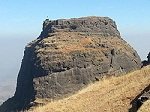
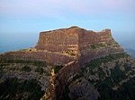 🏞️ Kulang Fort (कुलंग गड) – Igatpuri, Nashik
Kulang Fort, also known as Kulang Gad, lies in the Igatpuri region of Nashik and stands on the western side of the Kalsubai mountain range, the highest peak in Maharashtra. The fort forms a historic triangle with Alang and Madangad, three towering hill forts that once watched over a trade route connecting Nashik and Kalyan, which was a key commercial passage in ancient times.
📜 Brief History
During the 18th century, Kulang Fort changed hands along with several other forts in the Nashik belt. Around 1760, it came under the control of the Peshwas, who received it from the Mughal empire. Later, in 1818, the British took possession of the fort after establishing dominance in the region. Unlike many other captured forts, the British did not demolish the stone steps, which are still used today by trekkers.
🥾 How to Reach
Base villages: Ambevadi and Kurangwadi are the common starting points for the trek.
Trek duration: Approximately 2–3 hours from the base to the top.
Trail: The route passes through dense, scenic forests that are part of the Kalsubai–Harishchandragad Wildlife Sanctuary.
Water: Drinking water is available both on the path and on the fort itself.
Stay: Kulang has large natural caves capable of sheltering around 80–100 trekkers.
Tip: There is no firewood available at the top; trekkers should carry a gas stove or fuel wood from the base village.
📌 Major Attractions
Massive Stone Stairway: One of the longest and best-preserved among Sahyadri forts.
Panoramic View: Stunning views of the Kalsubai Peak, Bhandardara region, Alang–Madangad range, and surrounding valleys.
Caves: Spacious natural caves ideal for night stays.
Fresh Water Tanks: Clean water storage tanks carved from rock.
Historic Plateau: A wide open area showcasing remnants of fort structures.
 🏰 Malegaon Fort (मालेगाव किल्ला)
Malegaon Fort is a historic land fort situated in the heart of Malegaon city, 104 km from Nashik, on the northern bank of the Mausam River, a tributary of the Girna River. The fort stands in the middle of a busy marketplace and forms an important landmark of Malegaon’s urban settlement.
📜 History
The fort was constructed around the mid-18th century by Naro Shankar Raje Bahadur, a military commander in the Peshwa administration. Craftsmen and masons from northern India and Surat were specially invited to develop the structure, and many families later chose to settle in the locality, shaping the early expansion of the town.
The building of the fort took several decades to complete. With the decline of the Maratha power, the fort came under the attention of the British East India Company, especially after the fall of Trimbak Fort in 1818. During this period, Malegaon also saw the construction of religious spaces such as an Idgah built under the supervision of Dilawar Khan, a Rohilla soldier.
🚗 How to Reach
Malegaon lies on the busy Mumbai–Agra National Highway (NH-60), making the fort easily accessible by road. Locally, the structure is also known as Raje Bahadur Wada and is located near the well-known Ramsetu Bridge in the town. The premises currently house a Marathi high school, and visitors are generally allowed entry between 10:00 AM to 5:00 PM.
🔍 What to See at the Fort
Although situated in a crowded area, the fort is well-preserved.
Key features include:
Massive inner walls rising nearly 60 feet high
Thick exterior walls measuring approximately 6 feet in width
Large wooden gateway doors
Two cannons placed near the main entrance
A unique hexagonal well inside the complex
Exploring the site typically takes around an hour.
 🏰 Madan Gad Fort
Madan Gad, often called Madan Fort, is a rugged hill fort located in the western part of Nashik district in Maharashtra. It stands in the Kalsubai mountain range and is known for its steep climbs, rocky trails, and thrilling rappelling routes. Along with Alang and Kulang forts, this peak forms a popular trio for adventure seekers and experienced trekkers.
🚶♂️ How to Reach Madan Gad
The nearest railway stations are Kasara and Igatpuri, situated on the Mumbai–Nashik rail route.
From either station, travel via the Kasara/Igatpuri – Ghoti – Pimpalner Mor – Ambevadi route.
Ambevadi or Samrad village is the base point for treks to Madan, Alang, and Kulang. Local cabs are available from Kasara and Igatpuri.
🔎 Guide Recommendation
Due to technical climbs and rappelling sections, trekking here is not advised without an experienced local guide. Most guides provide ropes, harnesses, breakfast, meals, and safety gear for groups.
🚌 Bus Connectivity
A daily bus runs from Ghoti to Ambevadi (approx. 32 km), usually early morning around 6 a.m.
📌 About the Trek
The trek starts from Ambevadi and goes up to a ridge between Alang and Madan, which usually takes around 3 hours.
From the ridge, Madan appears to the right side, while Alang is to the left.
The final ascent to Madan Gad involves three steep sections including rock patches, ladders, and narrow paths. Typically, the climb from the col (ridge) to the summit takes another 2–3 hours.
🏞️ Places to See on Madan Gad
The top has a slanted rocky plateau, smaller than Alang’s vast surface.
One can find rock-cut caves and a couple of water tanks that hold potable water throughout most seasons.
There are no fortification ruins or major constructed remains, but the views from the summit are remarkable.
📍 Mountain Ranges Visible from Madan Gad
East: Alang, Aundha, Kalasubai, Patta, Bitangad
North: Harihar, Trimbakgad, Anjaneri
South: Harishchandragad, Ratangad, Ajoba, Khutta pinnacle, Katrabai
West: Kulang
 Mora Fort (Moragad)
Mora Fort, locally known as Moragad (मोरागड), is a small hill fort situated in the Baglan region of Nashik district. The area is characterized by two parallel mountain ranges—Selbari to the south and Dolbari to the north. Moragad lies on the Selbari range, close to the well-known Mulher Fort.
Historically, this entire mountain belt played a strategic role in guarding the Burhanpur–Surat trade route, which passed between these two ranges. Though Mora Fort is comparatively smaller, it helped support the defense network of nearby forts.
🏰 History
There are no distinct historical records directly linked to Mora Fort. As it stands right next to Mulher Fort, its purpose seems to have been supplementary—functioning as a lookout post and supporting fortification.
🚶♂️ How to Reach
The trek begins from Mulher village, which is accessible by road.
From the village, it takes roughly two hours to reach the saddle (col) between Mulher and Moragad.
A short ascent from this col leads to Mora Fort.
The fort has two surviving stone gateways, and the route contains rock-cut steps.
There is no reliable water source on the fort, so trekkers must carry enough water.
Estimated time to explore the fort: about one hour.
🔭 Places of Interest
Remains of rock-cut steps and gateways
A few water cisterns and small caves
Minimal built structures, as most of the fort is in its natural state
The fort offers scenic views of major peaks and neighboring forts such as:
Mangi–Tungi, Salher, Salota, Hargad, Mulher, and Nhavigad
 🏞 Patta Fort (Vishramgad) – Overview
Patta Fort, popularly known as Vishramgad, lies between Nashik and Ahmednagar in Maharashtra. The fort is located at an elevation of around 1,392 meters (4,566 ft) above sea level. It is believed that Chhatrapati Shivaji Maharaj once visited this place and halted here for rest. People living in the nearby region are referred to as Pattekar, meaning “those from Patta Fort”.
📜 Historical Background
Patta Fort has witnessed control by several dynasties. It was initially under the Bahmani Sultanate. After the empire broke apart in 1490, the fort came under the rule of the Nizam of Ahmednagar. Later, in 1627, the Mughals took possession of it.
During the Maratha expansion, Moropant Pingale, a key leader in Shivaji Maharaj’s administration, captured Patta in 1671. Although the Mughals regained it briefly in 1672, the Marathas recaptured it in 1675. Patta Fort also served as a crucial border post during the Swarajya period.
In 1679, after Shivaji Maharaj’s victory at Jalnapur, he traveled toward Patta. Mughal forces attempted to trap him, but the remarkable skills of Bahirji Naik, the head spy of the Maratha army, helped Maharaj reach the fort safely.
Later, on 11 January 1688, Mughal commander Matabarkhan seized Patta and appointed Govindsingh of Bhagur as the fort chief. The Peshwas took control in 1761, and eventually, the British annexed the fort in 1818.
🏰 Tourist Attractions & Key Spots
Easy Trek: Patta Fort is known for its simple and beginner-friendly climb.
Ruined Rajwada: A remains of an old palace (Rajwada) stands near the fort, showing traces of its historical importance.
Pattai Devi Temple: A temple built by locals on the fort, dedicated to Pattai Devi.
Trymbak Darwaja: One of the fort’s gateways, still in relatively good condition.
Laxmangiri Maharaj Caves: Near Pattewadi village, caves house a shrine of Shri Laxmangiri Maharaj, attracting devotees especially on full-moon days.
Ambarkhana Hall: A newly rebuilt structure capable of accommodating nearly 200 people for overnight stays; a rock-cut water tank lies close by.
Developed Pathways: The forest department and villagers have created trails, steps, and resting spots for visitors.
Windmills: The road toward Pattewadi showcases several windmills built by energy companies like Enercon, adding scenic beauty.
Mention in Literature: Patta Fort, along with Aundha Fort, is mentioned in Saint Eknath’s “Bhavarth Ramayana”.
 🏰 Rajdeher Fort – A Historic Hill Fort Near Chandwad (Nashik)
Rajdeher Fort stands on a rugged hill range close to Rajdeherwadi village, about 10 km from Chandwad in Nashik district, Maharashtra. Surrounded by dry mountain slopes and vast plains, the fort is considered one of the strategically important forts in the region due to its high elevation and panoramic visibility over the surrounding landscape.
📜 Historical Background
Rajdeher Fort has a long history that stretches back to times even before the Yadava rulers gained prominence in the Deccan. Around 1216–1217, the fort was a part of the Yadava kingdom, and later it came under the control of Alauddin Khalji’s forces, followed by the Faruki dynasty of Khandesh.
During Mughal rule in the early 17th century, the fort was assigned to Ramajipant of Bhadgaon as recognition for his efforts against the Ashirigad region. Historical records mention that the fort was later associated with Chhatrapati Shivaji Maharaj’s administration.
The control of Rajdeher changed hands again in 1752, when it was transferred by the Nizam to the Peshwa government under the Treaty of Bhalki. A few years later, in 1762, Vitthal Shivdev was given charge of the fort on an annual revenue agreement. When the Pawar family of Chalisgaon rebelled in 1764, the Peshwas regained authority over the area through military action led by Vittalrao Vinchurkar.
The final battle for Rajdeher took place on 15 April 1818, when British commander Col. Prother captured the fort after a fierce fight against Nikam Deshmukh, marking the end of Maratha control.
🧗♂️ How to Reach and Trek Details
Nearest Town: Chandwad (Approx. 66 km from Nashik)
Base Village: Rajdeherwadi (11 km from Chandwad)
Trekking to Rajdeher begins from a small hillock located west of the base village. The trail is wide, inclined, and clear, with limestone markings guiding trekkers throughout the route. It takes about 2 hours to reach the entrance of the fort. Since the path is open and without tree cover, a morning or late-afternoon climb is ideal.
Night halt can be arranged in caves on the fort or at the temple in the village. Local villagers often help with simple meals and stay arrangements at affordable rates.
📍 Interesting Spots on Rajdeher Fort
A single entrance gate, built in stone, welcomes visitors to the fort. The gate still bears an inscription written in Farsi.
A rock-cut water tank supplies drinking water throughout the year, making the fort habitable even during summer.
It takes roughly one hour to explore the top area, which offers a spectacular view of the surrounding hills.
🏞️ Perfect For
✔ Trekking beginners
✔ Fort history lovers
✔ One-day adventure trips near Nashik
✔ Photo and nature enthusiasts
 🏰 Salota Fort – Overview
Salota is a rugged hill fort situated in the Baglan mountain range of Nashik district, Maharashtra. The fort stands opposite the more famous Salher Fort, and both form a strategic pair of ancient defense structures guarding the route through these hills.
📜 Historical Background
There is no separate recorded history of Salota Fort, as it was mainly constructed to support and protect Salher Fort, which played an important role in Maratha military activities. Salota acted as a watch tower and a defensive outpost, helping armies secure the surrounding region from invasions.
🧗♂️ How to Reach Salota Fort
The base village for the trek is Waghambe, in the Baglan region.
A continuous uphill trek from the village leads to a col (pass) between Salher and Salota.
From this point, a narrow path heading west takes you to Salota Fort.
Many trekkers hire a local guide, as the route can be confusing and steep in parts.
The fort does not offer proper shelter, so most visitors leave their heavy luggage at the col, climb Salota, and then return to camp or stay overnight at Salher Fort, which has more space.
🔎 What to See on Salota Fort
The final ascent is tough and usually requires basic rock-climbing support due to the steep rock section.
Three narrow gateways, built one behind another, lead towards the main fort area.
The top has two rock-cut water tanks, which still store water through most of the year.
The natural layout of Salota suggests it was strongly built for surveillance and quick defense rather than for habitation.
 Tankai Fort is a prominent hill fortress situated on a peak of the Satmala mountain range. It stands alongside the nearby Ankai Fort, and together they are popularly known as Ankai–Tankai, one of the most formidable hill fort complexes in the Nashik region. The twin forts rise towering above the plains, with Tankai reaching nearly 900 feet above the surrounding land and around 3,200 feet above sea level. The site lies close to Manmad in Yeola taluka of Nashik district, Maharashtra, and today preserves the remains of a once-important Maratha stronghold.